Mayor reminds local residents of resources available on its Snow Safety web page to help navigate winter
Syracuse, N.Y. – The City of Syracuse is powering up the smart city tools it uses to respond to snowy weather. As snow moves toward Central New York, Syracuse Mayor Ben Walsh wants to remind residents of how they can stay informed about weather conditions and the City’s snow removal operations.
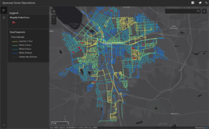
The City is launching a multi-faceted winter weather operations tool for staff and residents this season. The tool is a real-time data processing engine that produces an online map for residents to actively monitor street plowing; an internal fleet management system for the City’s Department of Public Works to track plows and resources; and an operational dashboard for the City to measure performance and improve operational costs. Residents can access the new plow map on the City’s Snow Safety page at www.syrgov.net/snowsafety.
![]() “Harsh winter weather is coming later than usual this year, but we can bank on receiving significant amounts of snow in Syracuse,” said Mayor Walsh. “We can use our increasing smart city capabilities to equip residents with the right tools to help them safely and easily navigate through winter. The data and insights our snow operations team will gain from the tool will also allow us to more efficiently and cost-effectively deliver services to residents.”
“Harsh winter weather is coming later than usual this year, but we can bank on receiving significant amounts of snow in Syracuse,” said Mayor Walsh. “We can use our increasing smart city capabilities to equip residents with the right tools to help them safely and easily navigate through winter. The data and insights our snow operations team will gain from the tool will also allow us to more efficiently and cost-effectively deliver services to residents.”
The real-time plowing map on the Snow Safety page offers residents the ability to see what streets have been plowed and how recently they were plowed. It also shows locations of illegally parked cars that are preventing plows from clearing a street. With this map, residents can check where and when streets were plowed to make informed decisions before commuting in snowy conditions.

Launched in 2018 by the City’s Office of Accountability, Performance, and Innovation, the original live map was well-received and began to help shape the City’s strategy for data-driven service delivery. To expand the public and internal capabilities of the tool, the City partnered with Esri, the mapping and data analytics company that produces the software behind the tool. This pilot program is one of the first in the nation and will help the City of Syracuse develop performance metrics to improve snow management operations. The data-driven framework developed for this tool will also help generate proactive and efficient delivery of other services city-wide.
Residents can find the remaining information about snow management on the City’s snow safety web page. The page includes guidance on how and where residents can report concerns; and information about the City’s snow removal operations, parking enforcement, and sidewalk snow clearance ordinances. The City also updated its “Snow Issues Tracker,” an online tool that allows residents to report un-shoveled sidewalks and illegally parked cars.


